 Subcatchment FAQ
This document discusses general issues about the use of a "subcatchment" within
HydroCAD.
What is a subcatchment?
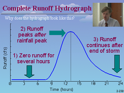
 A subcatchment is used to model the runoff from a given area of land.
Each subcatchment generates a runoff hydrograph, that is typically routed into a
downstream reach or pond. A subcatchment can also be used to account
for the rain falling directly on the surface of a pond. A subcatchment
cannot be used to route an inflow hydrograph. Instead, use a subcatchment to
calculate the runoff and a separate reach to perform
the routing.
A subcatchment is used to model the runoff from a given area of land.
Each subcatchment generates a runoff hydrograph, that is typically routed into a
downstream reach or pond. A subcatchment can also be used to account
for the rain falling directly on the surface of a pond. A subcatchment
cannot be used to route an inflow hydrograph. Instead, use a subcatchment to
calculate the runoff and a separate reach to perform
the routing.
How is the runoff calculated?
HydroCAD provides a choice of runoff techniques, including the SCS/NRCS Unit
Hydrograph procedure (aka TR-20), the Santa Barbara Urban Hydrograph (SBUH).
 How is the
rainfall defined?
How is the
rainfall defined?
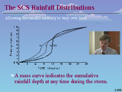
For the SCS and SBUH runoff procedures, a predefined rainfall distribution is
selected for the project area. When using the Rational method, a custom
IDF file can be created. For details, read about
rainfall options.
How is the
subcatchment characterized?
Each subcatchment must have a curve number (or
c-value) that characterizes the soil type and ground cover. HydroCAD also
provides for special handling of impervious areas.
Each subcatchment also requires a Time-of-Concentration. HydroCAD
provides a range of techniques for calculating the Tc.
Details here.
What is the maximum subcatchment size?
The SCS runoff procedure is suitable for subcatchment areas up to 20 square miles (12,800
acres) and a total watershed area up to 300 square miles. As the size
increases, routing effects and spatial rainfall variations become more
significant and a statistical (regression) analysis becomes necessary using the appropriate modeling software.
Why can't I route an inflow through my subcatchment?
A subcatchment is used only to generate a runoff hydrograph. To route a
separate inflow hydrograph you may want to use a reach.
Also read about overland flow.
For further information please read about runoff
calculations.
